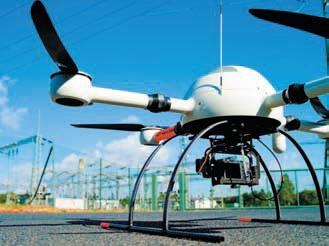
Not one for the drones

To date, thermal imagers have been at the pinnacle of predictive maintenance programs for overhead powerlines. They have proved to be essential in avoiding costly interruptions to electricity supply.
Using a traditional helicopter-mounted camera, linesmen and electrical contractors can typically inspect between 120km to 170km of powerlines each day.
ADVERTISEMENT
Now, contractors can use the latest in military technology to inspect and assess pole top rot, insulator damage, signing and guarding, conductor damage, steelwork and surrounding vegetation.
Tobias Matschke is the project manager and technical support offi cer for German manufacturer, Microdrones GmbH.
“Microdrones are easy to use, affordable and virtually maintenance free,” he says.
“For powerline inspection, an operator can drive to a power pole, set the system up in about 10 minutes, fly it for 10 minutes taking high-resolution photographs and then wrap it up in yet another 10 minutes. They’ll be in and out in half an hour.”
In Australia, Aerial Photography Specialists (APS) has launched its latest unmanned aerial vehicle (UAV), or microdrone, making it safer and easier to conduct detailed inspections of difficult or inaccessible locations.
The remote-controlled UAV requires just 1m² for launch and retrieval, making it suitable for offshore projects where the UAV can be launched from a ship or a safe area on an oil rig.
APS managing director Paul Martin says the solution is ideal for projects such as plant maintenance and powerline inspection where aircraft or cranes would usually be needed or where human access is difficult or dangerous.
“The ever increasing cost and complex logistics involved with hiring conventional aircraft make them a very expensive and inefficient way to take aerial photography,” he says.
“The UAV can fly out to the area of interest, perform the inspection from the air, manoeuvre around objects and send back live video and photographs for engineers to review in real time.”
APS has adopted an approach that is safe, cost-effective and interactive to achieve spectacular results often not possible in any other way.
In one project, the UAV was used to inspect a multi-million dollar wind turbine that had caught fire, losing its controls and brake system.
“The drone was programmed and sent out to inspect the damaged turbine from 5m away, relaying critical information to the engineers on the ground and allowing them to assess the turbine in a very vulnerable state without any risk to human life,” Paul says.
“The UAV is ideal for undertaking highly detailed, aerial asset inspections and can do the dangerous and risky tasks that would otherwise have to be done by a human, removing the possibility of someone being injured or killed in high risk situations.
“In addition to the obvious safety benefits, the UAV makes life much easier for plant managers and maintenance personnel as it causes no disruption to operations, less paperwork and it’s more convenient than crane or helicopter hire.”
UAVs with a range of camera options can provide low altitude aerial photography, HD video footage, mapping and infrared imagery up to 120m. The camera can be controlled from the ground, so that project managers and other personnel can be involved in the capture and image selection process. The global positioning system (GPS) allows aerial photographs to be taken at a certain location in the sky at regular intervals, enabling an engineer, for example, to record the growth and expansion of their projects.
“At Microdrones, we see UAVs as a tool rather than an aircraft. For that reason, we consider the operator of a microdrone as a photographer, versed in the framing of a picture and choosing the right moment of the day for best lighting conditions, and not a pilot,” Tobias says.
“Therefore, most of the actual flying is performed by the microdrone’s computer system. And the operator can focus on his tasks rather than controlling the microdrone.”
All of Microdones’ UAVs are quadrotor, vertical take-off and landing, micro unmanned aerial vehicles. This means the propellers are mounted at the ends of a ‘plus’-shaped body; two motors turn clockwise; the other two counter-clockwise.
“The flight and navigation controllers centre on an inertial measurement unit, consisting of an accelerometer and a gyroscope for each axis, supplemented by a tri-axis magnetometer, a barometric altitude sensor and GPS. The operator can control the UAV forward or backward, left or right and up or down. They can also trigger payload cameras to take pictures or change the zoom.
“As soon as there is no input from the operator, the microdrone will stay in one spot, waiting for the next command. It is possible to let the micro-drone hover unattended for minutes.”
Microdrones has recently introduced a new feature to its UAV Flight Controller firmware, further enhancing the ease of use and operational safety of its micro-drones. A new ‘homing’ feature enables the operator to simply activate a switch and have the UAV return back to base on its own.
“The total training required to fly a micro-drone, including safe start and landing, is less than an hour,” Tobias says.
“It takes a total of two days to learn every feature and function the micro-drone and the software mdCockpit have to offer.”
-
ADVERTISEMENT
-
ADVERTISEMENT

